Featured post

Overland to London - Ephesus to Anzac Cove

  Celsus Library, Ephesus Day 87 (London Day 3)    Wed 20 August     EPHESUS – ANZAC COVE After a night-drive through from Pamukkale we a...

Thursday, 16 April 2020

Anzac Day: A Time of Reflection

Irises now flower on the beach at Anzac Cove, Gallipoli Peninsula - island of Imbros on horizon.

A gentle Mediterranean breeze blows through the purple irises now flourishing along the Anzac Cove foreshore. The waters, aquamarine close inshore, graduate to a deep ultramarine where Imbros, now the Turkish island of Gökçeada, appears, smudge-like on the horizon.  It is hard to believe that 105 years ago this benign stony beach was one of blood, noise and death. 
I turn around as the gentle Aegean zephyrs waft inland, stirring the scrub covering former battlefields with evocative names, such as Plugge's Plateau, Quinn's Post, the Nek,  Baby 700, Battleship Hill, Johnston's Jolly and, further up the Sari Bair Range, Lone Pine and Chunuk Bair.  I can see the steep escarpment leading up to the ridge, dominated by the high distinctive bluff known as the Sphinx. I cannot even try to imagine the hell that the Australian and New Zealand soldiers went through, trying to gain a foothold, under fire, on this ridge which, through sheer grit, tenacity and the loss of many mates, they eventually did. 


The Nek & the Sphinx dominates Anzac Cove
I have visited the Gallipoli battlefields many times since my first visit in 1979. I have always found it deeply moving to walk among the gravestones, especially when one sees the ages of some of these Anzacs. I have seen the graves of 16. 17, 18 year olds, Victoria Cross winners, Captains, Lieutenants, soldiers of the Indian mule corps, Newfoundlanders, Gurkhas and Sikhs, many with thought-provoking epitaphs: 'He Sleeps where Anzac heroes came to do or die'; 'He died a man & closed his life's brief day ere it had scarce begun'; 'Sunset and evening star and one clear call for me'; 'We know that it is well with you among the very brave, the very true'.

A selection of Anzac & British graves in the different cemeteries on the Gallipoli Peninsular
The Ottoman soldiers fought with a tenacity that surprised all the Allied soldiers who landed on the Peninsula and a healthy respect for 'Johnny' Turk soon developed. There was also the realisation that the Turkish soldiers were defending their Homeland from foreign invaders. Turkish losses were colossal and most of their graves are now located at the Çanakkale Martyrs Monument neat Cape Helles.
Graves of Turkish soldiers at the Canakkale Martyr's Monument on the Gallipoli Penusla
 For Australians Lone Pine is their special memorial, with the names, not just of Australians but also of many New Zealand whose resting places are 'known only to God.'  The original 'lone pine' (Pinus brutia) was destroyed during the fighting of August 1915, but today's tree, now part of the monument, is from a seed of the original tree. Many seeds were taken back to Australia, and a tree in the gardens at the Shrine of Remembrance in Melbourne is one of these.

Lone Pine memorial and cemetery on the Gallipoli Peninsula
Further along Sari Bair ridge is the New Zealand monument at Chunuk Bair, which was one of the crucial objectives of the Battles of August 1915. Inscribed on the monument are the words 'From the Uttermost ends of the Earth', which are really most appropriate. It brings to my mind a passage from Maurice Shadbolt's Once on Chunuk Bair: "Imagine some Eskimo archaeologist four thousand years from now – Digging here and finding a barbarian tribe from the Pacific really did fight here."

Also inscribed on the Chunuk Bair monument are the names of the Maori dead of the battle, this being the first major action fought by the Maori Contingent, which later became the Maori Pioneer Battalion. There had been some controversy about the Maori Contingent being kept in Malta by the British War Office, who were not keen on 'native races' being involved in a 'European' conflict. Sir Ian Hamilton, overall commander at Gallipoli, records in his Gallipoli Diary: "Have asked that the Maoris may be sent from Malta to join the New Zealanders at Anzac. I hope and believe that they will do well. Their white comrades from the Northern Island are very keen to have them."
Monument to the New Zealand Expeditionary Force with Maori Contingent names, Chunuk Bair.

Turkish losses during the campaign were colossal. The Turks fought with a tenacity from the beginning, that caught the invaders by surprise, and was quite contrary to what they had been led to believe before the Campaign began. The Anzacs soon built up a healthy respect for the Ottoman soldiers and there was the realisation that the Turks were fiercely defending their homeland from foreign invaders. Most of the Turkish graves are now at what is known as the Çanakkale Martyrs Monument, further down the Peninsular towards Cape Helles. 


The nearest town to the battlefields, on the European side of the Dardanelles, is Eceabat, a town that in recent years has thrived on the Anzac story. The main ferry crossing of the Dardanelles is between Eceabat and the larger town of Çanakkale on the Asian side and it is in the Çanakkale Consular Cemetery that the last New Zealand soldiers, 11 men of the Canterbury Mounted Rifles, were buried in December 1918. The Canterbury Mounted Rifles had been sent to Gallipoli in December 1918 to assist in locating and burying the allied dead but unfortunately another killer struck - that of the 'plague of the Spanish Lady', the horrific Spanish influenza pandemic that swept the world at the end of World War One.
The town of Eceabat has one of the largest and most interesting memorials of the conflict.  Both Australian and Turkish trenches, complete with bronze soldiers from both sides, oppose each other in a static battle in the middle of town. Busts of Turkish heroes of the conflict line the waterfront, and the entire diorama is overlooked by a large statue of Mustapha Kemal (later Atatürk), the overall Turkish commander. It is a most impressive memorial.
The Australian trenches of the large War Memorial in Eceabat.
Today large container ships now pass unhindered through this strategic waterway, heading through to Istanbul and the Black Sea ports of Romania, Bulgaria, Ukraine, Russia and Georgia.
A container ship enters the Dardanelles heading towards Istanbul and the Black Sea

As they head along the Strait they cannot fail to see, on a hillside above the village of Kilitbahir, the Dur Yolcu monument of a soldier beneath a Turkish flag with the words by the poet Necmettin Halil Onan, which translated from the Turkish, reads:


Traveller Halt!
The Soil You Tread
Once Witnessed the End of an Era.

© Neil Rawlins  text & photography

Past posts relating to the Gallipoli Peninsula:

                                  Anzac: the Turkish Monuments of the Gallipoli Penisula

                                   Some Surprising Facts about the Gallipoli Campaign

My paperback books on my Overland travels in Asia, Europe & Africa in the early 1970s and the experiences of a tour guide on the Asian Overland routes & leading Camel Safaris in Rajasthan in the 1980s are available from Amazon.


Sunday, 5 April 2020

The Great Byzantine Cathedral of Istanbul


Hagia Sophia Cathedral at tulip time
For me, one of the most impressive buildings in the world is the great Hagia Sophia Cathedral, the Church of the Holy Wisdom,  in the Turkish city of Istanbul.  For almost 1500 years, this great domed Cathedral has stood in the heart of what was once Constantinople. Its great dome has stood a thousand years longer than that of St. Peter's Basilica in the Vatican.   It is the third church to be constructed on the site, the first dating from the 4th century and the second from the early 5th century.
During the Nika riots of 532, the 2nd Church of the Holy Wisdom was almost completely destroyed - just a few pieces of pediment remain. Much of Constantinople burned and around 30,000 rioters killed when the rebellion was suppressed by Belisarius, the Emperor Justinian's general.

A section of the pediment of the 5th century St. Sophia, destroyed during the Nika riots of 532
Shortly after the suppression of the riots, the Byzantine Emperor Justinian I commissioned two architects, Isidore of Miletus and Anthemius of Tralles to formulate plans for a new Cathedral, which was built in just 5 years and dedicated in 537. However, in 558 the main dome completely collapsed in an earthquake. It was subsequently realised that the original dome had been  built far too flat. Isidore the younger, nephew of Isidore of Miletus, was called in by Emperor  Justinian. This time lighter material was used and a ribbed dome, elevated  by around 6.5 metres, was erected.  Justinian also ordered 8 massive Corinthian columns to be brought from Baalbek in Lebanon as additional support. The Cathedral was re-consecrated in 562 and this is the amazing building that we see today. For over 900 years Hagia Sophia was the centre of Greek Orthodoxy, except for 57 years in the 13th century, after  Constantinople was sacked by the Christian armies of the 4th Crusade, when  it became a Roman Catholic Cathedral. In 1453, Constantinople was captured by the Ottoman Turks, and the Cathedral, with the addition of minarets, became the first Imperial mosque of the Ottomans.
In 1935, after the establishment of the Turkish Republic by Kemal Atatürk, this great Cathedral-cum-Mosque became a museum, and work began on the uncovering of the spectacular Byzantine mosaics which had been plastered over during the Ottoman rule.
The Deësis Mosaic & Byzantine arches on the upper level of Hagia Sophia
Over the years, I have visited this great building many times, and have always experienced a overwhelming sense of awe when I have passed through the Imperial Door into the main body of the Cathedral.

The Imperial Entrance to Hagia Sophia
On the granite step, each side of the entrance, are depressions, made over the centuries, I have been told, by the  Varangians, the 'Anglo-Saxon axe-bearers', bodyguards of the Emperors, who stood here,  Stepping through the door, into the gloom of the main body of the church beneath the great dome, is like stepping back in history, and is definitely awe-inspiring. Perhaps best described by Doreen Yarwood in The Architecture of Europe: 'The interior of S. Sophia is monumental; the architectural design is simple but the effect dynamic in its quality of light and open space. The central dome is 180 feet above ground, supported on gigantic pendentives which in turn stem from the four semi-circular arches and enormous, ground-standing piers.'
The interior of Hagia Sophia is a unique blend of Christian & Islamic iconograohy
On the main piers are circular panels with the names of Allah in Arabic, a reminder that this was, for many centuries, a Islamic place of worship. The interior of the great dome still retains, in gold-lettered archaic Arabic, the many names of Allah inscribed on the plaster  which still covers the original Byzantine mosaic, probably of Christ Pantocrator. The very fine Byzantine mosaics in other areas of the building have had the covering plaster painstakingly removed, revealing the incredible workmanship of these ancient craftsmen.
Panels with names of Allah & a mosaic portrayal of the Virgin Mary with the infant Christ in one of the semi-domes.
In the middle of the Cathedral is the marble omphalos, the navel of the world, the spot where  the Emperors of the Byzantine Empire were crowned. Also in this section of the Cathedral are  two huge marble lustration urns from Bergama (ancient Pergamon), for the storage of anointing oils.
The omphalos, or navel of the earth - the spot where the Emperors of Byzantium were crowned.
One of the huge marble lustration urns from Bergama

The passage to the upper level is wide with rough cobbles, designed to stop horses hooves slipping as they transported dignitaries to the upper levels.
The passageway to the upper level of Hagia Sophia
It is on this upper level that some of the finest mosaics can be seen. These include the famous Deësis, the Comnenus and the Empress Zoë mosaics, and on each of the large triangular pendentives are seraphim, or archangels.  Also on this upper level is a 19th century marker which is supposedly the site where the grave of the 41st Doge of Venice, Enrico, or Hendricus Dandolo who died in 1205, was originally located. The original grave was destroyed after the Ottoman invasion, and he remains the only person who was buried in Hagia Sophia. Enrico Dandolo was the blind and aged - reputedly around  97 - Doge of Venice who led the Venetian soldiers and sailors in the 4th Crusade. The aim of the 4th Crusade had originally been to attack Cairo, but due to the inability of the Crusaders to pay back money owing to Venice, the force first attacked Zara (modern Zadar) then, against Pope Innocent III wishes, besieged Constantinople in 1203. After the city fell the following year and an orgy of looting and killing followed. The result being a Catholic State was established that lasted until 1271. All part of the intrigue that makes this building so interesting. 
The famous Comnenus mosaic in the upper level of Hagia Sophia

A seraph, or archangel on one of the pendentives in Hagia Sophia

Everything about this building is impressive. But it was on my last visit to Hagia Sophia, that it suddenly struck me, that people had been regularly worshipping under this massive dome for longer than the genus homo sapiens have lived in my native New Zealand. Definitely thought provoking.
The massive outer walls & a minaret of Hagia Sophia

My paperback books on my Overland travels in Asia, Europe & Africa in the early 1970s and the experiences of a tour guide on the Asian Overland routes & leading Camel Safaris in Rajasthan in the 1980s are available from Amazon.


Thursday, 12 March 2020

Vanished Auckland - Changes in a Lifetime

The early 20th century gaff-rigged Rawhiti in front of the modern Auckland skyline
Cities have to change, I guess. That's progress. As a teenager, in the mid-1960s,  I first began taking a serious interest in photography and began recording the contemporary world around me. Photographic film and development was then fairly expensive and so the number of pictures taken was limited. I did concentrate on using transparency (slide) film  and have never regretted that early decision. Now, 55 years later, I can see how important it was taking these early photos, as Auckland, the city I grew up with has changed immeasurably as the population has grown. On looking through my archives I have selected a number of photos which, to me, illustrate the changing times, the transition of city caught in a time-warp to a modern, vibrant metropolis.

Today, as the modern downtown Commercial Bay development nears completion, I can look back on what previously occupied the site. When I first began working, in January 1966, I was a clerical worker at the Department of Lands & Survey which was, in those days, in the old Customhouse, a grand old building in its own right, dating from the late 1880s. One day, I took my camera to work, leaned out of the window of the 'Leases' section on the 3rd floor and took a photo of what was then Little Queen Street. It was here that I caught a ABC (Auckland Bus Company) bus home each day to Te Atatu where I had grown up.
In those days Little Queen Street ran between Custom and Quay St. giving extra access to the Ferry Building. On the right hand corner with Customs Street was the Galaxie where we would often go in our lunch hour to see pop-groups such as the La De Das, Underdogs or Pleazers perform.
Little Queen St. in 1967, soon to disappear under the Downtown Centre

I left New Zealand in 1970 and when I returned in 1974, the Downtown Centre had eliminated this small street, and the Galaxie. One evening in 2008, I took a photograph of advertising on the Downtown Centre which I called 'Collision Course'. Little did I then know that the Downtown Centre's days were also numbered, and the Commercial Bay Development would take its place. Incidentally, close to where the original Commercial Bay beach had been when Auckland was first settled in the 1840s.
'Collision Course', advertisng on the Downtown Centre in 2008, corner of Customs & Albert St. Now replaced by the Commercial Bay Development.

One of the major engineering projects of the late 1960s was the addition of the extra 'clip-on' lanes to the Auckland Harbour Bridge. The bridge had been opened as a 4-lane structure in 1959, but within 5 years the realisation had sunk in that it was too small. Freeman, Fox & Partners, the consulting engineers, were recalled and recommended the enlargement of the existing bridge 'by providing additional separate superstructure, one on each side, supported by the existing piers. Each new superstructure would carry a 2-lane 24-ft carriageway.' The extra lanes were manufactured in Japan, shipped out and lifted into position by two large floating cranes. I took this photo as work progressed from Point Erin in 1968.
The extra 'clip-on' lanes being added to the Auckland Harbour Bridge in 1968
In 1987, my wife and I went to dinner with some friends in a quaint little restaurant called La Brie in Warspite Street in the central City. Shortly after I heard that the restaurant along with Warspite Street was going to be demolished to make way for the new Chancery Centre. 
Windows of La Brie Restaurant in Warspite St., in 1987, soon to be demolished


On Kings Wharf there was the the large brick building of the Auckland Farmers Freezing Company (AFFCO) cool store. I first noticed this building when, in 1987, my wife and I took a trip on the old auxiliary schooner Te Aroha. The boat was berthed at the Kings Low Landing, then dominated by the AFFCO building. The building had been used to store refrigerated carcasses for export in the days before containerisation.

The brick AFFCO cool store with auxiliary schooner Te Aroha at the Kings Low Landing.
 Demolition of the building had begun in early 1988 when we took another trip on Te Aroha. When we returned to the King's Low Landing, fire trucks were hosing down the smoldering wreckage, accidentally set on fire during demolition. An ignominious end to part of Auckland's commercial heritage.
A fire truck hosing down the wreckage of the AFFCO Cool Store in 1988
At the end of the 1980s, Sea Bee Air was still operating an amphibious air service to Great Barrier Island along with charters to other islands in the Hauraki Gulf from Mechanics Bay. The forerunner of Sea Bee Air, Tourist Air Travel had been established by the flamboyant Freddie 'a shower of spray and we're away' Ladd in the mid-1950s. This part of Auckland's aviation history ended when the last Grumman Goose of Sea Bee Air took off from Mechanics Bay in Easter 1990.

Grumman Goose of Sea Bee Air comes ashore at Mechanics Bay, December 1987
An iconic building in the suburb of Ponsonby was the Hydra Bacon Factory whose large neon sign dominated College Hill at night for many years. I had been fascinated by the Company logo of the multi-headed Hydra of Greek mythology and when I heard the factory was to be demolished, I took the following photographs.

The Hydra Bacon Factory in Ponsonby in 1989

The multi-headed Hydra above the office door of the Bacon Factory, 1989
Across the Harbour, in the suburb of Devonport, in the late 1980s, it was time to replace the old ferry wharf which hundreds of commuters used each day. This construction was in dire need of replacing, but the old wharf did have character, even if it was cold and draughty in winter.

The old Ferry Wharf in Devonport in 1988, not long before demolition.

The rather bare interior of the old Ferry Wharf at Devonport, 1988

One of the most surprising demolitions of the late 1980s was that of the  Salvation Army citadel which stood in Greys Avenue, just off Mayoral Drive behind the Town Hall. This fine looking building with its central turreted tower had been built in 1928, and was one of the most distinctive buildings in Greys Avenue. Protestors did try to stop the demolition, to no avail – an interesting part of Auckland’s heritage disappeared under the wrecker’s ball.
The Salvation Army Citadel in Greys Ave in 1987. The site is still a carpark!
After Team New Zealand won the America’s Cup in 1995, the decision was made to re-develop the Viaduct Harbour area, part of which was used by fishing boats, but the rest was in a sorry state. The Auckland City Council Municipal Market Building, had been Auckland’s main commercial fruit and vegetable market until a larger facility had been developed at Mt Wellington by the early 1990s. The old City Council Market building was one that disappeared during the America's Cup boom  in the late 1990s & early 2000s. A sign of the changing times, the newly-constructed Sky Tower now dominated the City skyline when I took this photo in 1999.

The Auckland City Council Municipal Market building in 1999
But perhaps for me, the biggest symbol of a changing Auckland, was the removal of the iconic Pinus radiata which had been planted by John Logan Campbell on the top of Maungakiekie, or One Tree Hill. Campbell planted this tree to replace a sacred totara which has been cut down by early European settlers. This tree, along with the obelisk to the Maori people, part of Campbell’s bequest, had been a symbol of Auckland since the 1940s. When the decision was made in 2000, by Auckland City Councillors, to remove the tree, which had been damaged a number of years earlier by a Maori activist,  I just had to come up the hill one final time. Like many Aucklanders, I could say I was born, literally, in its shadow. Being a post-war baby, I was born in the former US military hospital which was situated in Cornwall Park and used, temporarily, until the National Womens Hospital was built in nearby Greenlane. So, for me,  to  be able to walk around the tree on the afternoon before its removal, at the beginning of the 21st century, was an emotional experience and personally epitomises the changes I have seen to the city I grew up in.

The lone Monterey pine on One Tree Hill, before vandalisation by a Maori activist.

© Neil Rawlins  text & photography

My paperback books on my Overland travels in Asia, Europe & Africa in the early 1970s and the experiences of a tour guide on the Asian Overland routes & leading Camel Safaris in Rajasthan in the 1980s are available from Amazon.


Thursday, 23 January 2020

The Haast, a small but Turbulent River


By world standards it is not a big river. It is only around 100 kilometres from its source in the rainforested Southern Alps to the Tasman Sea, but its impact on the environment can be huge. In a benign mood, the river is a beautiful placid blue, but during the frequent heavy rains it soon turns into a malevolent,  turbulent dirty grey-green monster which each year  can bring down some 10 million tonnes of silt. The average annual rate of flow is almost three times that of the River Thames in Britain. This is the Haast River of New Zealand’s South Westland.

The blue waters of the Haast River in its lower reaches, its benevolent mood
The grey-green waters of the Haast River during rain: its malevolent mood
Until 1960, the small settlement of Haast, near the mouth of the river, had no road access with the rest of New Zealand. The early families, known as the Far Downers, had come in by sea from the 1870s and a cattle track was established along the coast and inland to Lake Paringa. There was also a rough horse track that more or less followed Tiori Patea, the old less-favoured Maori route to the West Coast.  This route followed the river, with summer-flowering rata trees and dense rainforest, before winding up to, and over, Haast Pass to the more open country along the Makarora River.
The rata trees - Metrosideros umbellata - can put on a spectacular show along the banks of the Haast River
The Pass, the river and, in later years, the small town, were all named after the German geologist Sir Julius von Haast who, in 1863, travelled from Central Otago over the Pass and down to the Tasman Sea.  
 The modern road, now State Highway 6,  follows the river for almost its entire length and was constructed in the late 1950s, giving road access to the town of Haast for the first time. New Zealand’s most isolated community was now connected to the modern world. Ironically though, it was one of the first communities in New Zealand to have a regular air service, with West Coast Airways establishing a regular service from Hokitika in the 1930s. The road north to Lake Paringa, Fox and Franz Josef Glaciers, Hokitika and Greymouth was not completed until 1965.
A homestead in the settlement of Haast
Haast Pass, at 563 metres is the lowest of the three major road passes over the Southern Alps. After crossing the Pass one follows SH 6 into the rainforests of Westland. On the right a small stream, known as Cross Creek, appears and after a few hundred metres joins embryonic Haast River which plunges out of impenetrable mountain rainforest. The river soon widens as the traveller heads north. By the roadside is a small hut, still used by road workers. This once housed the explosives used for the large amount of rock blasting that was needed on this section of the road.  There are a number of waterfalls on both sides of the road with evocative names such as Fantail, Diana & the Trickle; the latter two often cause problems on the road in heavy rain. After passing an ‘escape’ road - in case brake failure! - the road passes over the spectacular one-lane Gates of Haast Bridge which crosses the now turbulent Haast river. After passing Thunder Creek Falls, the road again crosses the river at Pleasant Flat and a little further on the Landsborough River, the only major tributary of the Haast flows in from the right.  


The Gates of Haast Bridge over the Haast River
The rapids of the  river beneath the Gates of Haast Bridge
The river has now widened considerably and each bluff or little creek along the road has been given a name. There is Douglas Bluff, named after the indomitable Charlie Douglas, a surveyor and prospector known to local history as Mr Explorer Douglas. He was a man of grit and determination with a wry sense of humour. Once when asked if the rising barometer meant bad weather, Charlie Douglas replied, in his dour Scottish way ‘The barometer doesn’t affect the weather much on the Coast.’

Further along the road there is Dismal and Dizzy Creeks, Imp Grotto, where a prospector was said to have found uranium during the road construction. There is Chink Creek, the Roaring Swine, Dancing Creek, Depot Creek, Gunboat Creek and Snapshot Creek, where, I have been told, the road crosses the Alpine Fault which is the meeting of the Pacific and Indo-Australian tectonic plates.
Snapshot Creek, where the road to Haast Pass crosses the Alpine Fault
After passing by the small modern town of Haast, SH 6 crosses the spectacular 750 metre single-lane Haast River Bridge, the longest in the country. 
The 750 metres single lane Haast River Bridge 
Having viewed the river from the road, let us now experience the river from the waterway itself.  Haast River Safaris operate jetboat tours along a 30 kilometres section of the lower river. 

After a short bush walk, hopefully evading attacks by the persistent Westland sandflies, the traveller scrambles into the large, fully-enclosed jetboat of locally operated Haast River Safaris.

A tour group boards a Haast River Safari jetboat while their tour coach continues over the bridge
With a thunderous roar of twin V8 engines the jetboat is off, heading up the wider reaches of this interesting river.There are single banks to wend around, rapids to zip through and trees, brought down by successive floods, to dodge.

With a roar of twin V8 engines the Haast River Safari jet boat is off.
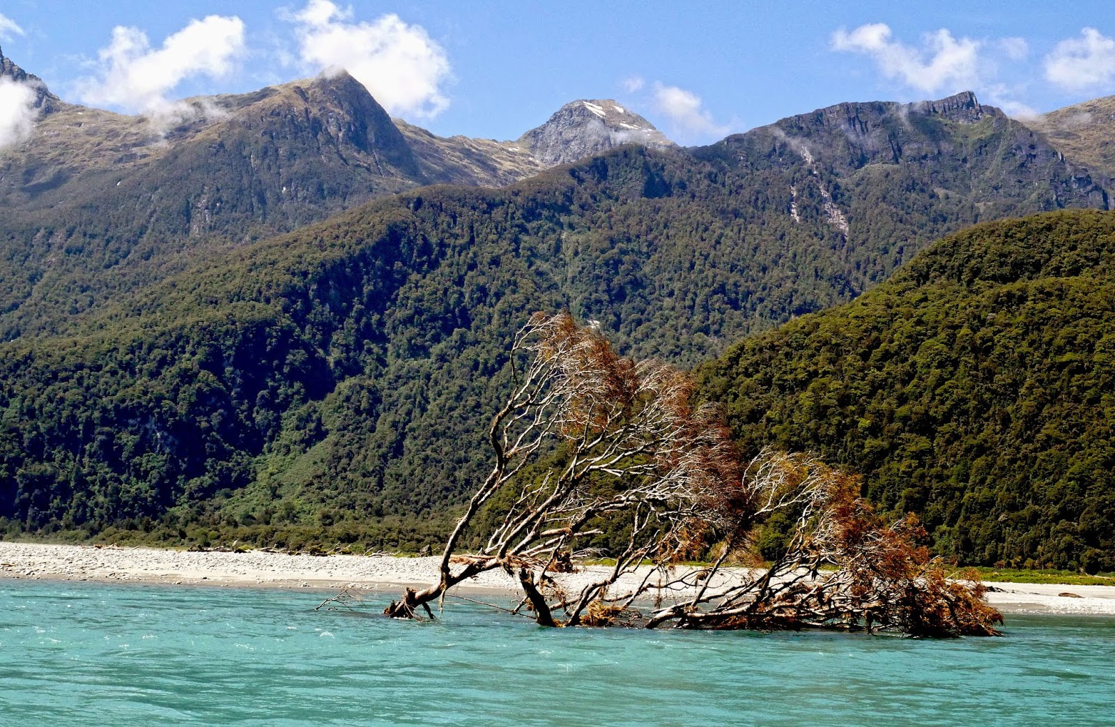
Near Haast settlement the river is wide, but as the boat proceeds upstream, narrow channels between single banks become more frequent.  The Haast River is never constant, always changing. The boat operator knows the river; what to look for after a flood when the course of the river can change dramatically. The main channel of the river has been know to switch from one bank to the other in a matter of minutes. A flood will bring great trees crashing down, and as the waters drop, new unexpected hazards have been created; single banks will have moved. I have travelled the river many times over the years and have never ceased to be amazed at how things do change. A section of river bank, undermined by a recent flood, with large trees growing precariously on the edge, will have disappeared completely by my next trip, with these trees now forming new hazards in the river. It is very much a landscape in flux. The rainforest along the banks is dense, but it still cannot halt these extreme forces of erosion. 
Rainforest growing precariously on the edge of the eroded river bank.

This large kahikatea tree has succumbed to the erosive forces of the Haast
  Features seen from the River are quite different from those of the road. Joe and Harris Waterfalls, two permanent waterfalls, plunge through the rainforest and were, incidentally, both named by Joe Harris, a foreman during the road construction. The Roaring Swine takes the shape of a spectacular glacier-formed hanging valley, disappearing into the clouds of Mt Aspiring National Park. The fresh, clear waters of the small Thomas River mingle markedly with silt-laden main river. 

Threatenng weather up the Roaring Swine, a classic glacier-created hanging valley
Shingle banks of smooth coloured river stones, mostly greywacke, but also granite, schist, quartz and orange ultramafric, tells a geologist much about the makeup of the Southern Alps.  

Investigating a shingle bank on the Haast River
No jetboat journey would be complete without several fun 360 degree spins. These large, powerful machines spin more sedately than their smaller, open counterparts, but nevertheless it is still exciting - and dry!!
Inside a Haast River Safari jet boat during a fun 360 degree spin
. Journey's end is at Roaring Billy, a waterfall which plunges through the dense rainforest of the left bank and was named for its likeness to a billy of boiling water when in full spate. At times of little rain, it could be likened to ‘Whispering Willy’! 

Roaring Billy plunges through the rainforest on the banks of the Haast River.

© Neil Rawlins  text & photography


Books published by Neil Rawlins on Amazon