By world standards it is not a big river. It is only around
100 kilometres from its source in the rainforested Southern Alps to the Tasman Sea,
but its impact on the environment can be huge. In a benign mood, the river is a
beautiful placid blue, but during the frequent heavy rains it soon turns into a
malevolent,
turbulent dirty grey-green monster
which each year
can bring down some 10
million tonnes of silt. The average annual rate of flow is almost
three times that of the River Thames in Britain. This is the Haast River of New
Zealand’s South Westland.
 |
| The blue waters of the Haast River in its lower reaches, its benevolent mood |
 |
| The grey-green waters of the Haast River during rain: its malevolent mood |
Until 1960, the small settlement of Haast, near the mouth of the
river, had no road access with the rest of New Zealand. The early families, known as the Far Downers, had come in by sea from the 1870s and a cattle track
was established along the coast and inland to Lake Paringa. There was
also a rough horse track that more or less followed Tiori Patea, the old less-favoured Maori route to the West Coast. This route followed the river, with summer-flowering rata trees and dense rainforest, before winding up to, and over, Haast Pass to the more open country along the Makarora River.
 |
| The rata trees - Metrosideros umbellata - can put on a spectacular show along the banks of the Haast River |
The Pass, the river and, in later years, the small town, were all named after the German geologist Sir Julius von Haast who, in 1863, travelled from Central Otago over the Pass and down to the Tasman Sea.
The modern road, now State Highway 6, follows the river for almost its entire length and was
constructed in the late 1950s, giving road access to the town of Haast for the
first time. New Zealand’s most isolated community was now connected to the
modern world. Ironically though, it was one of the first communities in New
Zealand to have a regular air service, with West Coast Airways establishing a
regular service from Hokitika in the 1930s. The road north to Lake Paringa, Fox and Franz Josef Glaciers, Hokitika and Greymouth was not completed until 1965.
 |
| A homestead in the settlement of Haast |
Haast Pass, at 563 metres is the lowest of the three major road
passes over the Southern Alps. After crossing the Pass one follows SH 6 into the rainforests of
Westland. On the right a small stream, known as Cross Creek, appears and after a few
hundred metres joins embryonic Haast River which plunges out of impenetrable mountain rainforest. The river soon widens as the traveller heads north. By the roadside is a small hut, still used by road workers. This once housed the explosives used for the large amount of rock blasting that was
needed on this section of the road.
There
are a number of waterfalls on both sides of the road with evocative names such
as Fantail, Diana & the Trickle; the latter two often cause problems on the road in heavy rain. After
passing an ‘escape’ road - in case
brake failure! - the road passes over the spectacular one-lane Gates of Haast
Bridge which crosses the now turbulent Haast river. After passing Thunder Creek Falls, the road again crosses the river at Pleasant Flat and a little further on the Landsborough River, the only major tributary of the Haast flows in from the right.
 |
| The Gates of Haast Bridge over the Haast River |
 |
| The rapids of the river beneath the Gates of Haast Bridge |
The river has now widened considerably and each bluff or little creek along the road has been given a name. There
is Douglas Bluff, named after the indomitable Charlie Douglas, a surveyor and
prospector known to local history as Mr Explorer Douglas. He was a man of grit and determination
with a wry sense of humour. Once when asked if the rising barometer meant bad
weather, Charlie Douglas replied, in his dour Scottish way ‘The barometer doesn’t
affect the weather much on the Coast.’
Further
along the road there is Dismal and Dizzy Creeks, Imp Grotto, where a
prospector was said to have found uranium during the road construction. There
is Chink Creek, the Roaring Swine, Dancing Creek, Depot Creek, Gunboat Creek and Snapshot
Creek, where, I have been told, the road crosses the Alpine Fault which is the
meeting of the Pacific and Indo-Australian tectonic plates.
 |
| Snapshot Creek, where the road to Haast Pass crosses the Alpine Fault |
After passing by the
small modern town of Haast, SH 6 crosses the spectacular 750 metre
single-lane Haast River Bridge, the longest in the country.
 |
| The 750 metres single lane Haast River Bridge |
Having
viewed the river from the road, let us now experience the river from the waterway
itself. Haast River Safaris operate
jetboat tours along a 30 kilometres section of the lower river.
After
a short bush walk, hopefully evading attacks by the persistent Westland
sandflies, the traveller scrambles into the large, fully-enclosed jetboat of locally operated Haast River Safaris.
 |
| A tour group boards a Haast River Safari jetboat while their tour coach continues over the bridge |
With a thunderous roar of twin V8 engines the jetboat is off, heading up the wider reaches of this interesting river.There are single banks to wend around, rapids to zip through and trees, brought down by successive floods, to dodge.
 |
| With a roar of twin V8 engines the Haast River Safari jet boat is off. |
Near
Haast settlement the river is wide, but as the boat proceeds upstream, narrow
channels between single banks become more frequent. The Haast River is never constant, always
changing. The boat operator knows the river; what to look for after a flood
when the course of the river can change dramatically. The main channel of the
river has been know to switch from one bank to the other in a matter of
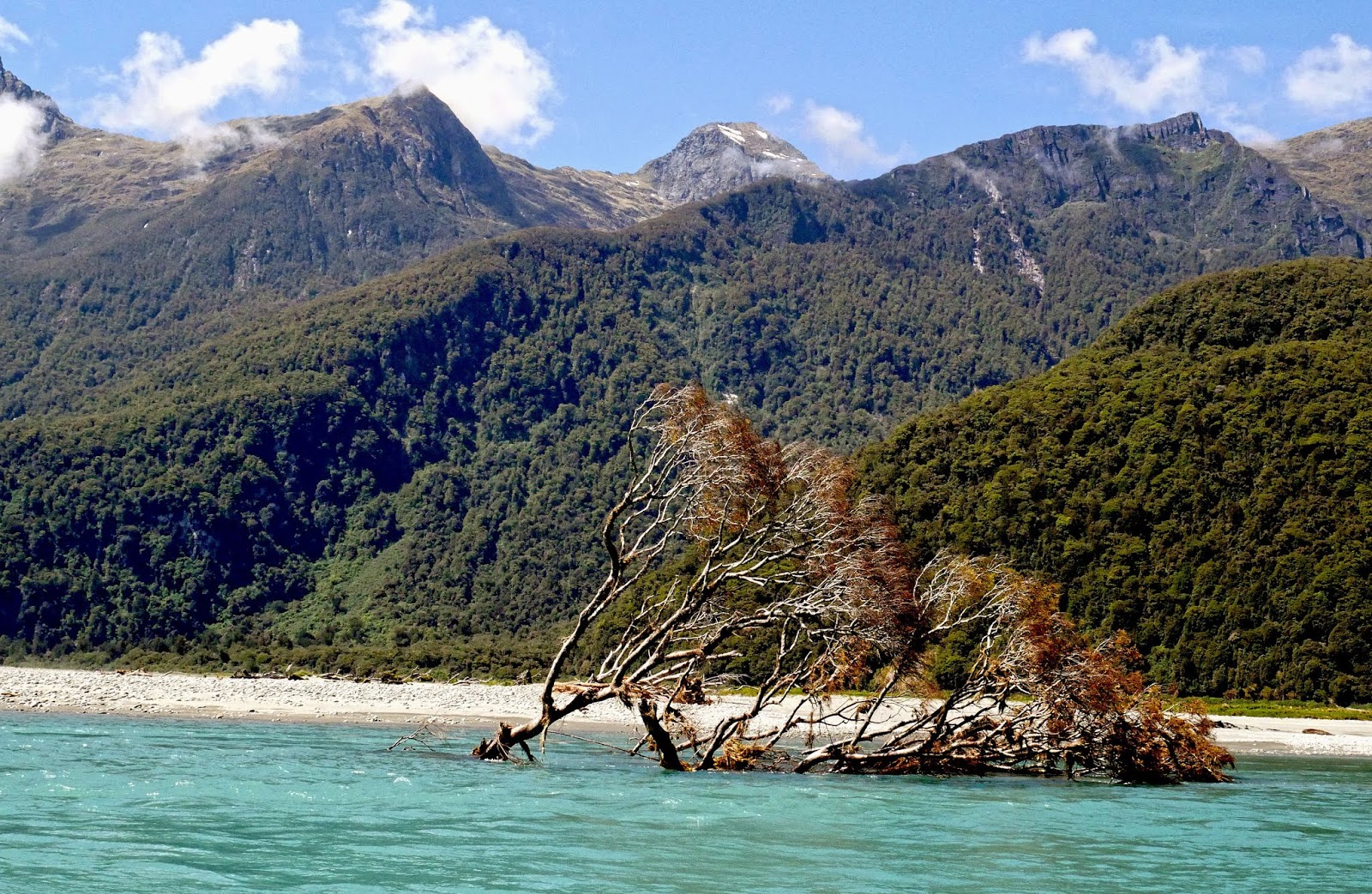
minutes. A flood will bring great trees crashing down, and as the waters drop, new unexpected hazards have been created; single banks will have moved. I have travelled the river many times over the years and have
never ceased to be amazed at how things do change. A section of river bank, undermined by a recent flood, with large trees growing precariously on the edge, will have disappeared completely by
my next trip, with these trees now forming new hazards in the river. It is very much a
landscape in flux. The rainforest along the banks is dense, but it still cannot halt these extreme forces of erosion.
 |
| Rainforest growing precariously on the edge of the eroded river bank. |
 |
| This large kahikatea tree has succumbed to the erosive forces of the Haast |
Features
seen from the River are quite different from those of the road. Joe and Harris
Waterfalls, two permanent waterfalls, plunge through the rainforest and were, incidentally,
both named by Joe Harris, a foreman during the road construction. The Roaring Swine
takes the shape of a spectacular glacier-formed hanging valley, disappearing
into the clouds of Mt Aspiring National Park. The fresh, clear waters of the small Thomas River mingle markedly with silt-laden main river.
 |
| Threatenng weather up the Roaring Swine, a classic glacier-created hanging valley |
Shingle
banks of smooth coloured river stones, mostly greywacke, but also granite, schist, quartz and orange ultramafric, tells a geologist much about the makeup of the Southern Alps.
 |
| Investigating a shingle bank on the Haast River |
No jetboat journey would be complete without several fun 360 degree spins. These large, powerful machines spin more sedately than their smaller, open counterparts, but nevertheless it is still exciting - and dry!!
 |
| Inside a Haast River Safari jet boat during a fun 360 degree spin |
. Journey's end is at Roaring
Billy, a waterfall which plunges through the dense rainforest of the left bank and was named for its
likeness to a billy of boiling water when in full spate. At times of little rain, it
could be likened to ‘Whispering Willy’!
 |
Roaring Billy plunges through the rainforest on the banks of the Haast River.
© Neil Rawlins text & photography
|