Featured post

Overland to London - Ephesus to Anzac Cove

  Celsus Library, Ephesus Day 87 (London Day 3)    Wed 20 August     EPHESUS – ANZAC COVE After a night-drive through from Pamukkale we a...

Thursday, 31 December 2020

Canoeing the Whanganui River


Canoeists passing Tamatea's Cave on the Whanganui River

 Now listed as one of New Zealand's Great Walk, the Whanganui River is actually a great canoeing experience. The River, New Zealand's 3rd longest, now has the status, with the rights, duties and liabilities, of a legal person, reflecting the importance of the river to the Maori people. 

In the 1990s and early 2000s, we included a 4-night. 5-day canoeing experience in our  New Zealand tours. The canoeing began in the small riverside settlement of Whakahoro, where the Retaruke River meets the mighty Whanganui, and finished in the larger (not much), settlement of Pipiriki on what is known as the River Road.  This river trip was delightful on fine, sunny days but, of course, could be pretty miserable when it rained. Campsites were basic, but had long-drop toilets and a DOC (Department of Conservation) erected shelter, under which we could cook, with a hand basin and a rain-water tank. The Whanganui was regarded as a novices' river and a wilderness experience.

              This photo essay is compiled of photos I have taken over the years.


 First of all the canoes had to be carefully packed. Personal equipment, sleeping bags, cameras, food etc. were stored in waterproof barrels, hopefully with a water-tight latch - if secured properly!


    Once the canoeists have gained confidence, there is time to relax in the sun in the more benign                stretches of the river.


    After a couple of hours paddling it is time to stop for a refreshment and a leg stretch on one of the          many shingle banks on the River.

    
    The first night's camping at Ohauora was always something of an experience. For many of our clients  this was their first taste of real wilderness camping, and a camp fire from the river driftwood was always popular.


            The 'long-drop throne room' was again something that many of our clients had not experienced before. This original 'architectural gem' was situated in a sylvan setting at Ohauora & when you heard someone approaching, you would surreptitiously cough.  DOC upgraded this edifice in later years.


    Some of the formations on the Whanganui has some rather interesting and innovative names. This was Man o' War Bluff, as it bore a resemblance to an early iron-clad battleship. The bow slopes down to the water, just to the right of the red canoe, and a hawsehole can be seen directly above the canoe.
    

   Another interesting feature of the River was the feature known as the Drop Scene. Here the the river disappears around an obscured bend behind the canoes. As one approaches this bend the scenery appears to move, like the 'Drop Scene' of an old vaudeville theatre. It was also the scene of a Maori tribal battle in the early 19th century.


    The Mangapurua Landing had originally been developed as road access to the Mangapurua Farm Settlement, developed from 1917 for World War One veterans. two or three kilometres from the Whanganui.  Groups walk from here to the Bridge to Nowhere.   
    

   The Bridge to Nowhere was a road bridge built in the late 1930s to give motor access to the Whanganui River for the farmers of the Mangapurua Farm Settlement. Very few motor vehicles used the bridge, as weather conditions caused road collapses further up the valley, isolating the Bridge. The Farm settlement was eventually abandoned in the early 1940s, and nature was allowed to take over.
    

    On later river trips we stayed a night at the Bridge to Nowhere Lodge at Ramanui. Evenings were particularly restful and beautiful.

    
    I was always fascinated by the natural rock girdle along the river banks, especially when the water was crystal-clear and mirror-like. It was difficult to see where the water actually began.
 
    
    On the last day, when everyone thought they were accomplished canoeists and complacency had taken over, we had to pass through the Autapu Rapid. If the river level was low, the rapid could be demanding and exciting. Here the author, with a nervous client up front, enters the Rapid.


    Some clients had taken notice, and remembered, instructions on how to tackle the Autapu Rapid successfully.

    
    For others, things didn't quite go according to plan, and the Autapu claimed other victim. Fortunately this rapid was short and the bedraggled casualties could haul their upended or swamped canoe ashore on a shingle bank to dry out.
 

    On the lower reaches of the River there were side creeks to investigate such as the Mangaeao River.
  

    As we neared Pipiriki, the River wound through farmland. 

    
    Finally, journey's end was reached. The canoes are hauled ashore at the Pipiriki Landing and unloaded for the road journey to Whanganui City. 

Text & photographs ©Neil Rawlins 

Selected travel photos from these & other blogs are available from my photo gallery


My paperback books on my Overland travels in Asia, Europe & Africa in the early 1970s and the experiences of a tour guide on the Asian Overland routes & leading Camel Safaris in Rajasthan in the 1980s are available from Amazon.


Friday, 11 December 2020

Hiking on Fox Glacier - a photographic record.


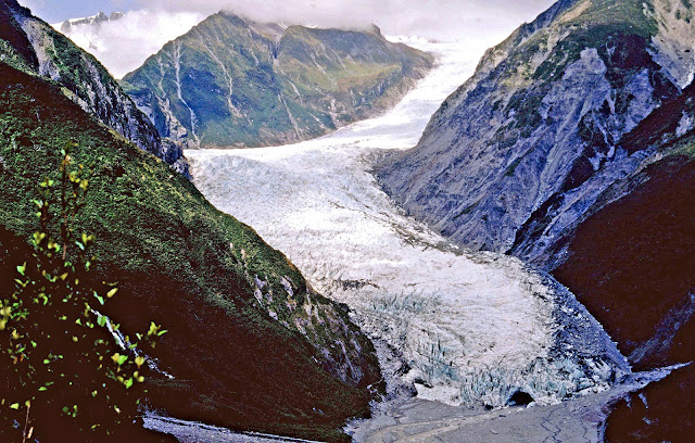
The Fox Glacier in the early 1990s from Cone Rock
Tumbling down from the vast névés of New Zealand's Southern Alps, flow great rivers of ice, dropping over a short distance from the snowfields of over 10,000 feet into the temperate rain forest of the South Island of New Zealand's West Coast. The two mightiest of these remaining glaciers are the Franz Josef and the Fox. 
  
During the 1990s and the early 2000s, contrary to what was happening elsewhere in the world, these two glaciers were, in the main, advancing, at times quite rapidly. I was leading adventures in New Zealand at the time, and we included a Glacier hike on the Fox Glacier as part of our tour itinerary. It was an exciting time, as each tour would see changes to the Glacier and the access route to the ice would have changed. On one tour we would climb up the snout of the glacier and on the next, we would scramble over the rocky, rubble-strewn lateral moraine. At the height of the advance, we would hike up through the temperate rain forest before dropping down onto the ice.  It was always a great experience. 

      Over the years I took many photos and have included a few of these in this photographic essay. 


    A warning sign denoted the beginning of the access tracks to the ice, which many individuals seemed to ignore.


    It was a unique experience to walk through rain forest to access this great river of ice. 

    The access point was where the glacial ice came close to the crumbling rocks of the lateral glacial moraine. Due to the fragile nature of the terrain caused by the movement of the glacier, this would change each time I brought a group here.

    Groups members pause, having just accessed the ice, at the edge of the Fox Glacier.

     Once on the Glacier the route would change each time. There were ice pinnacles known as seracs, to pass around.
  Sometimes we could get quite close to the ice pinnacles, but we always had to beware of falling ice.

    The Glacier guides would cut steps into the hard glacial ice on the steeper section of the route, making access for groups easier, and lessening the risk of slipping. A guide would always be on the ice, surveying the new days route, and maintaining the previous day's stairs if they were to be used.


    The hike over the ice to a high point with views of the peaks of the Southern Alps    


    The tracks through the ice would often take us close to crevasses which opened as the Glacier moved.

    If we were lucky we would find an ice cave to walk through. These ice caves were not that common on the area of glaciers that we walked.  


Near the edge of the ice, curious denizens of the rain forest, such as the friendly little South Island tomtit, would watch us.


As we walked over the ice, low clouds, on most days, would wreath the mountain peaks above Fox Glacier.


    On some hikes, our route would take us to an icy high point which overlooked the Valley of the Fox River, carved out of the mountains by successive ice ages.


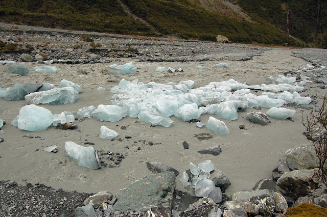
    Small ice pinnacles and shattered rock will soon tumble down into the Fox River.

    The waters of the Fox River emerge from a ice cave at the snout of the Glacier. Occasionally, an ice collapse would cause a blockage in the Cave, and after pressure built up, usually after heavy rain, the ice would blow out down the valley, a good reason not to go near the ice cave. 


    In December 2007, the Fox Glacier still looked spectacular, even from the access track, but from this time the Glacier began retreating rapidly, as the effects of global warming take effect. 


Text & photographs ©Neil Rawlins 

Selected travel photos from these & other blogs are available from my photo gallery


My paperback books on my Overland travels in Asia, Europe & Africa in the early 1970s and the experiences of a tour guide on the Asian Overland routes & leading Camel Safaris in Rajasthan in the 1980s are available from Amazon.


Monday, 12 October 2020

Photos of Singapore in 1970 & 1988


I first arrived in Singapore on the Chinese New Year in 1970

Singapore is a city that has changed immensely over the last 50 years, perhaps more so than any other city in the world. I have been to this interesting city just twice - in 1970 and in 1988 and to celebrate the 50th anniversary of my first visit, I have dug out a further series of photos from both my visits from my photographic archive. This will supplement those I published in a blog three years ago, which has proved to be most popular.  

A street scene in downtown Singapore in February 1970

Sampans in the harbour in Singapore  February 1970


A Cluster of Sampans in Singapore Harbor, 1970


Not so many of the traditional boats in Singapore Harbour in 1988


The rooftops of Chinatown from the New Seventh Story Hotel, Rochor Rd., February 1970


When I next visited Singapore in August 1988, high-rise buildings had appeared along the banks of  the Singapore River

...and Raffles Hotel was about to close for a big modernisation programme. 


Text & photographs ©Neil Rawlins 

Selected travel photos from these & other blogs are available from my photo gallery


My paperback books on my Overland travels in Asia, Europe & Africa in the early 1970s and the experiences of a tour guide on the Asian Overland routes & leading Camel Safaris in Rajasthan in the 1980s are available from Amazon.


Sunday, 20 September 2020

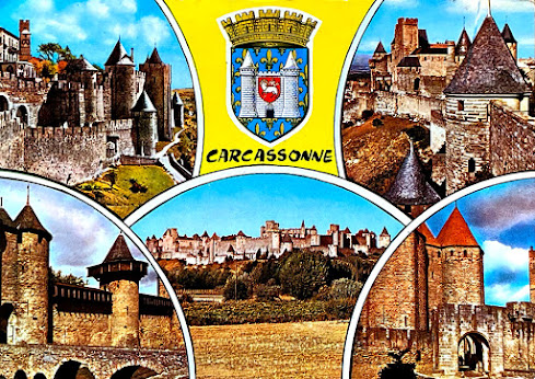
Postcard sent from Carcassonne, France  October 1971 
Postcard sent from Carcassonne, France in October 1972
 
   In recent weeks, to keep myself occupied during the covid-19 lockdown, I have been collating my travel letters & postcards to my parents and copying them onto my computer. The first letters date back over 50 years, when I flew first to Singapore and then to Kathmandu to join an Penn Overland tour to London. As I read through my letters I begin to realise just how much my parents must have looked forward to them. I was on the other side of the world and a sometimes infrequent letter was the only reassurance my parents had that I was Okay. This was the days before faxes, and many years before email, Facebook, Instagram, Twitter and the now modern means of communication.

 I can still see my mother walking to our roadside letterbox at 10 River Rd.  Te Atatu, or, in later years at 1360 Whangaparaoa Rd, Army Bay, to collect an envelope with a grouping of colourful exotic postage stamps. Looking intently at these small colourful postal labels, she would rush inside to open and read of the adventures I had been having. I had asked her to preserve my letters after they had done the rounds of family and friends, which she did assiduously and, I dare say, probably re-read them.
  
 
Envelope of letter posted in Moscow, June 1971

I remember the excitement when, as a child and teenager, I received letters from overseas. The colourful stamps and exotic postmarks added to a sense of mystery and an eagerness to read the contents. The letter may have been from a family friend who had recently gone overseas, or maybe it was from a penfriend of whom I had a number during schooldays and after. I was also an avid stamp collector in those days and consequently always hoped a letter would have many colourful stamps. 


Aerogramme posted in Kabul, Afghanistan. March 1970

In 1970, when I headed away from New Zealand, first to Kathmandu to travel Overland to Britain, I began writing on a regular basis.   It is now, as I transfer my letters on to computer, that I began to realise how important my letters were to my parents.  Sometimes there were sizable gaps between my communications, especially when I was in Third World countries. There must have been times when they were concerned, especially when I was in darkest Africa in 1973. It is possible some letters may never have arrived, although looking through the correspondence of these years, I would think the most did. In those days it was really the postcard that took the place of a quick text to say all was okay.  I would send postcards between lengthy missives, and I know my Mum, in particular, always enjoyed these colourful postcards. Today an email is received the second it is written, even from the remotest of  destinations.  

 Following are a few colourful envelopes and postcards from these pre-computer days when the only means of of urgent communication was by telegramme,  or phone call, then expensive and having to be booked hours, or even days, in advance.  


           An envelope posted in Kigali, Rwanda during my Trans-African odyssey in 1973

                                                     A letter from Gibraltar in November 1971


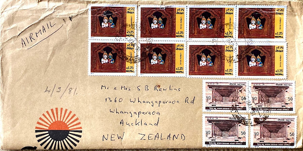
                    A cluster of Nepalese stamps on a larger envelope posted in Kathmandu in 1981

        Stamps in particular, could be topical, such as the marriage of Prince Charles to Diana in 1981
        
Sometimes the placement of stamps can make things a little difficult, as there's not much rooms on a postcard at the best of times. This postcard was posted in Yazd, Iran in November 1979, during the American Hostage crisis, hence the reference to 'the troubles with Americans'.


     A post mark on a letter can also conjure up images of exoticism. The postmark can tell its own romantic story.   I have selected half a dozen, mainly from the '60s, before individual post offices & theor postmarks disappeared.           

                                                                              Nuku'alofa, the capital of the Island Kingdom of Tonga.


Banana, a small town in central Queensland, Australia.


Eureka, in the Waikato District of New Zealand


             Cyanide, Tarkwa, Ghana. Postmark from the Cyanide Mine dated 1964


Anchorage, the capital of Alaska


            Yeppoon, another small town in                               Queensland,  Australia


    Today, letters, postcards and postmarks are now a thing of the past, now replaced by emails and instagrams.


Text & photographs ©Neil Rawlins 

Selected travel photos from these & other blogs are available from my photo gallery


My paperback books on my Overland travels in Asia, Europe & Africa in the early 1970s and the experiences of a tour guide on the Asian Overland routes & leading Camel Safaris in Rajasthan in the 1980s are available from Amazon.